View Blogs in a larger map
Red - The most recent post
Blue - 2008
Magenta - 2009
Green - 2010
Purple - 2011
Yellow - 2012

Monday, August 20, 2012

Glacier

My Dad came up to meet me in Glacier. We spent a week looking at waterfalls, glaciers, flowers and goats.
I was supposed to meet up with my Dad when I got out of the Bob, but it took a little longer then I expected to get to East Glacier and cell phone coverage being what it is, we missed each other. Not a big deal we ended up meeting up in East Glacier the next day over breakfast. He already had a campsite at Two Medicine Lake so we went back there to do some exploring. In the bogs of the valley floor, a moose walked right past us. Moose can have tempers and I'm surprised this one was so relaxed, considering how agressive a few of the photographers around us were. I saw a tadpole in a pool in front of a waterfall.
Then we went over to Running Falls, which wasn't talked about in any literature, but it was amazing. It was a waterfall that seemed to just pour out of the rock. In the picture on the sign it looked like during high water, it would pour over the top as well, but the effect was so much neater watching it come out of the rock.
The next morning was a little grey and cloudy. We got out early to get over to Manny Glacier and get one of the limited camping sites available. We got in and found a place easily, but none were left an hour later. From the parking lot we could see mountain goats slowly grazing the high cliff walls.
It was a perfect day to make the hike up to Iceberg lake. It was a whole different world up there. Flowers were blooming everywhere, it was chilly and the lake was full of broken glaciers. The water was so smooth the reflections made some great photos.


When we got back from the hike, people were still looking at the goats on the hillside. We went over to check out the Manny Glacier lodge. Quite the structure that used to be accessible only by horse back on multi-day tours. It sits right on Swiftcurrent lake looking across to monolith rocks rising straight up. There were a few grizzles just off the road at Manny Glacier, but not in a place to make a decent picture.
The next day we were back at Swiftcurrent lake to hike around to Grinell Lake and Glacier. It is one of the more popular hikes in the park. Rightfully so, because it was gorgeous. The water gets that turquoise because of sediment suspended in it from the glacial ice that feeds it. It is truly stunning to look at.
That was a long hiking day, so the next day we took it easy and did a little more auto touring. We drove the going to the sun road. We stopped at Wild Goose Island overlook, and a few waterfalls.
Then over Logan Pass where there were some mountain goats just hanging out near the trail. We followed the road down to Avalanche Lake and around to West Glacier. There were more and more tourists and the mountains weren't as dramatic. We decided Manny Glacier is the place to be.
We were back on the Going to the Sun road the next day to hike the Garden wall. It was truly extraordinary covered with wildflowers. There seem to be two phases of summer in Glacier. Either waterfalls or flowers. I'll have to come back another time for the waterfalls.
We stopped by the Wild Goose Island view point again at sunset and it looked pretty nice. We decided we needed to come back for a star shot and the sunrise.
We weren't alone for the sunrise shot...
After the sunrise, we went back to camp and packed up. I broke down my bounce box that had taken several flights and been mailed around the country. I was all packed up and heading towards canada, Dad was heading back to the airport. It was great to have some company for awhile, and it's always fun to go on photo safaris with my Dad.

View CDT Check in in a larger map

Monday, August 13, 2012

Bob Marshall Wilderness

The Bob Marshall Wilderness, commonly referred to as The Bob. It's another amazing wilderness area just south of Glacier, but with none of the people. It's highlight is the Chinese Wall. The CDT goes right along this section, and it was something I didn't want to miss this summer. I also had a hunch that I might run into some hiking friends.
The first night out, I wasn't feeling it. After all the driving, I just didn't feel up to walking. I was getting lonely and a little depressed. But I stuck with it.
The next day I was back on the CDT. Felt connected to all my friends I knew somewhere down the line. That night I improvised a bear bag solution. There weren't any good trees around that were isolated enough to hang food from, so I just used the roof.
The third day I finally made it to The Wall. It's a bluff of rock about 1000 feet in the air about 10 miles long. It is quite the impressive structure when you finally see it.
For some reason there were tons of flies in that area. There was a lot of water and springs near the base of the wall, that must have bread the flies. They would hang out on my back and back of my arms until I stopped, then they would swarm my face. It made the breaks brief.
After the wall I was heading downhill when I heard two voices come from around the corner. It was Lint and Dirtmonger who I last saw somewhere in Colorado. I was hoping to run into them, but they were completely surprised by me. We sat down in the trail and traded stories for an hour. It was great to meet up with them again.
The next day, I needed to get out and up to glacier to meet up with my dad. It was a hot hike out. The last 6 miles was exposed around a lake with lots of horses. My umbrella helped, but I was still overheated when I got back to the parking lot.

View CDT Check in in a larger map

Thursday, August 9, 2012

Northern Idaho

I had decided if I was going to be driving, I was going to try taking as many backroads as possible and stop to read the signs at the side of the road and take the time to explore, even if I was in a car.
So I left the Selway, over Lolo pass and into Missoula, then west down 90 to Wallace. My favorite little american town. I mean, they say they are the center of the universe, have a brothel museum, were the last stoplight to be take out of the interstate system, and have what is called gyro days (that's pronounced like gyroscope, not like the sandwich). If you're ever heading down 90, it's worth the stop. From there I headed north and checked out another Red Cedar grove. They are really neat forests.
Then headed up to Sandpoint to see Chet and Melissa and their new son Grey. I stayed with them for two nights and had a great time catching up and hanging out.
From Sandpoint I went around Preist River Lake and up towards the border with Canada. Stopped by a few waterfalls including one that is almost directly on the border with Canada, called American Falls. It is the end of the Idaho Trail I had originally started, but I didn't find a monument.
Then there was this neat flume at a random state park I stopped off at.
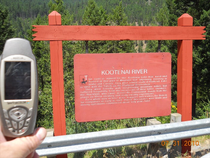
I needed to get back over towards Glacier to meet up with my dad in a week. From where I was the easiest way to do that was to go up into Canada and around to Bonners Ferry. So I was in Canada all of a week. The guys at the border didn't quite understand that and they almost searched my car, but let me through without much issue.d I stopped by the Kootenai falls, which was a pretty impressive water fall. There's a guy on the far right of the first picture

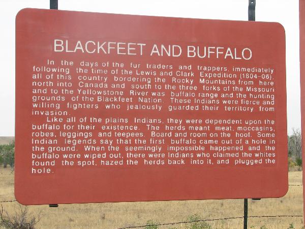
Something I noticed on my drive was the different context the information signs included. The most interesting was the difference the way Blackfeet were described. They are known as being fierce and skilled warriors, but opinions seem to differ as to why. This first sign is from outside Kootenai falls
"...the Blackfeet, who came across the Continental Divide from the plains on horse stealing and scalp raising expeditions."
To this one from the plains of those blackfeet.

"These indians were fierce and willing fighters who jealously guarded their territory from invasion."

View CDT Check in in a larger map

Sunday, August 5, 2012

Selway/Bitterroot/Lochsa

I didn't have a lot of plan of where I was going to go, but I knew I wanted to keep heading north through Idaho.
So I left Boise, headed up 95 and onto the Magruder road. It is the only real road that cuts across the interior of the Idaho. It divides Frank Church wilderness to the South and the Selway/Bitterroot wilderness to the north. From where I camped I could see a fire burning up the Sawtooths where I was two weeks early. I managed just to keep ahead of the fires this year.
I got down to the Selway and talked with the volunteer ranger there and he didn't have good reports on the trails. They sounded more overgrown then what I had just been in and I didn't have it in me to spend another frustrating week in the woods. It was a beautiful area, and I'll have to go back another time. So I drove out and around to the Bitterroots. The peaks steep and pointy with severe glacier activity.
Day hikes were a nice change of pace. And doing some off road driving is always a fun way to explore. It certainly is a lot easier and faster then hiking, but I did miss being in the middle of the wilderness and knowing I got myself there under my own power. I drove around to the Lochsa which is another neat river. It's where the great western red cedars really begin to show up. I stopped by some hot springs to soak, and hiked up to see a waterfall. It's where I was planning on walking in from if I had stuck to my original trail.
From there I drove the Lolo road which is another drive I've always wanted to do. The road follows the old Nez Pierce trail that Lewis and Clark used to traverse the rockies. They had information signs along the road with quotes from the Lewis and Clark journals. One said that the trail follows the ridge of the mountains because the slope was so steep and forested, that it was impossible to keep a trail clear in the valley next to the water. When they would stop at night they had to hike down to get water.
Even driving alone isn't without it's challenges. I came across a spot that the road had washed out. It was filled with cut logs. It would be fine to cross with a 4 wheeler, but it was a bit iffy to try without someone to spot me.
So I turned around and found a great campsite on the ridge with a beautiful view of the sunset and sunrise. Another fire had starte to the south of me that filled the sky with beautiful colors, accompanied by NPR from Missoula on the radio.