This will not be a short entry. The Frank Church is an amazing, huge wilderness area and was an adventure.
After getting dropped off I hiked 10 miles to Dagger Falls. Technically out of the Wilderness area and the put in for all of the raft groups. There were lots of people from the raft camps up to look at the falls. I had to turn down keg stands and free drinks, because I still wasn't sure I wasn't sick. People were saying sometimes they would see salmon jumping up the falls on their way to spawn.


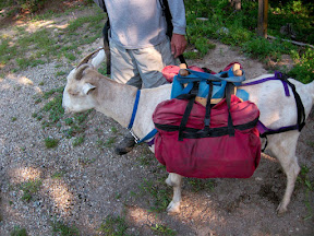
There was also a group of people there using goats as pack animals. I have some issues with horses packers on trails. They shit everywhere and can leave deep ruts and make walking difficult. The goats, however, were very light footed and sociable. I would like to see more goats as pack animals. Each carried 20-40 pounds depending on the size of the goat and they could do about 10 miles a day. Their owners still carried other things, but the goats brought the wine and the chairs.


I hiked past the put-in for the boaters. The Salmnon is known for it's steep mountains, and this was no different. They built a slide to get the boats to the water. Boats were being rigged as I walked by. Demand to take a trip down the Middle Fork is high, so trips are very regulated. 3 contract and 2 or 3 private groups leave a day. People can be on the wait list for 10 years to get a permit.


The contract groups had these huge gear boats steered by one guy with two rudders. These boats took all the gear ahead of the group and set up camp before the group got there. They would pitch all the tents, set up the cots and have snacks ready when the group would arrive.


I found this weird hole in the ground that was a couple feet wide and looked like it opened into a more cavernous pit. It was strange. There were no tailings from the hole or other sign of where the dirt that was inside it went. Very strange.
There were also the typical remnants of other people that had been there, and impressive whitewater.


Then in the middle of this wilderness area, I walked through a private inholding, called Pistol Creek Ranch. The "trail" goes down the side of the private landing strip and there are about 20 - 30 houses that are all amazing. As far as I know the only access to bring in materials was to float them down the river or fly them in on a plane. As I walked by one house, I could see through the picture windows they were watching satellite tv. It felt very surreal.


The morning was full with the sound of planes traffic. There must have been 3 to 5. I imagine the flight to Boise is under an hour and some people probably do it as a commute in the summer to see the family at the summer house. Planes became a common noise. Even though this is in the middle of a wilderness, existing air strips are maintained and there are a number of public ones throughout the wilderness area.

I hadn't been hiking an hour that third morning when I came to another stream crossing. I was trying to hop from rock to rock to avoid getting my feet wet when I hit a moss covered one. I slipped and fell, landing on my hiking pole splitting it in two.

Annoyed but uninjured I kept hiking. My route diverged from the middle fork as it trended more to the east, and I headed up Marble Creek. It started off nice enough. Passed a historic cabin that had v-notched logs, which means it was done most likely with an ax instead of chisels. Then the canyon began to get tighter and tighter as the trail crossed back in forth across the knee deep river more then 20 times.


Then it started to rain. The trail became more and more faint. Pushing through trees covered in water, walking through streams and doubling back looking for the path in waist high grass. I was soaking wet everywhere and frustrated. Then I came to one side stream crossing and couldn't find the continuation of the trail. I went back and forth, and looked at my map and GPS. Eventually I found a sign saying Trail Creek, which is where I thought I was which was good, but still no sign of any trail. Then I was looking at my forest map again and noticed that it was marked in red, while other trails were in black. When I looked at the legend, it said that red trails were not maintained. I had about 20 more miles of red trail before meeting back up with a black one. And at my current pace that would take a day and a half to cover. So I decided to turn around, camp for the night and head up and over the ridge and back to the middle fork.


Here's where the big difference is with any other trail. Even the CDT, in these types of conditions, there is probably a way to get to a paved road and a town in a day or so. Here I was at least two days away from any type of civilization. The other problem was I was checking in faithfully with my GPS locator, and that night I didn't check in because I was tired, in a bad mood. Then when I finally checked in the next day it looked like I had only covered 9 miles, concerning those back home who were watching closely.
So the next day I took it a little easier, doing another 10 miles (again without being able to explain to people back home). They day turned out to be nice. The views from the ridge were nice and I camped next to a lake and saw a nice bull elk.


The next morning the clouds were hanging in the valley which looked neat to be on top of, and it was a nice walk along the ridge and back down to the river. I passed an old fire lookout which had great views as to be expected.


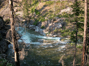
When I got back down to the Middle Fork, I noticed the rain from the storm had really added to the power of the river. It had also turned brown from a side tributary blowing out a sandbar somewhere up stream. The entire area has seen large fires over the past 10 years, and heavy rains can lead to intense erosion in big storms.

Back on the river, I saw raft groups again. As I hiked into the evening, I was hoping I might come across one that would be nice enough to give me a beer. As I came up around a bend in the river, I startled a girl who had just finished changing behind a tree from her a camp. She introduced me to the group and they invited me in for a snack and a beer and we traded stories about our trips. Then was another drink, then they forced me to stay for dinner, because why would I want to hike any further? They were right! I ate till I was stuffed and had more to drink.
After dinner came rock bowling which consisted of setting up three rocks in a triangle and throwing another rock at them. They were a group of three or four families that had been taking river trips together forever. By the end of the night, siblings were wrestling, and I felt like one of the family. I teamed up with Darci for rock bowling and we dominated.


After rock bowling came smores and campfire songs. It was a great time, and really the spirit lifter that I was looking for. I gave them a card or two, but never heard back from them. The whole group was a lot of fun and I hope I might here from them in the future.


The trail continued down stream and past some prehistoric pictographs. With rivers this big and mountains so tall, it makes you realize that this trail isn't new. The same path was most likely used by people for thousands of years.


The rafters floated by, down the muddy middle fork on their last day to the take out. I crossed the river on a bridge and headed up Big Creek. Where the waters met there was a distinct line of the muddy brown Middle Fork and the crystal clear Big Creek met.


Eight miles up Big Creek is the Taylor Wilderness Research Station operated by the University of Idaho. It wasn't on my original agenda, but I had read about it before heading out. It's a research station with students that spend the summer doing wildlife and ecology studies. For 15 dollars you can sleep on a couch inside and they have electricity and satellite internet. It's a nice little refuge with really friendly people.


While I was there, one of the students mentioned that there were a couple wolves in the area that a teacher was studying. When I left that morning it was hot out. I sat down for a break in the shade. While I was sitting there I looked up and saw what looked like a German Shepherd trotting down the trail towards me. It was a wolf and it didn't notice me until I said something aloud. It looked up and casually loped up the hill. Back walking again less then an hour later, there was another wolf coming down the trail again, this time it was the female. Crazy. An hour later, I was walking near the river and I heard a crash in the willows and looked up to see a black bear running up the hill.


But still after all these spottings, I wasn't having a good day. It was hot, I was tired and the trail was rough. Even though this was a black trail, it was thick with vegetation. And lots of it held the morning dew long into the day, soaking me from the waist down. So I told myself I only needed to do 12 more miles instead of 17. I'd take longer breaks in the shade. My umbrella really helped keep me cool as it was warming up into the 90s and the burned areas provided no coverage from the sun.


The next day it was another hot day through burned out areas. It had been 8 days since I left Stanley and I made it to Chamberlin Ranger Station in the afternoon where I had sent myself a box of resupplies. When I got there, the ranger cabin was open but no one was around.
View CDT Check in in a larger map
No comments:
Post a Comment